When you think of Las Vegas more than likely the first things that come to mind is the Las Vegas strip, neon lights, and towering casinos. However, you might be surprised to learn that there are amazing and natural worlds just beyond the Las Vegas strip worth exploring.
These other worlds far removed from the glitz and glamour of the Las Vegas strip include Red Rock Canyon National Conservation Area, Valley of Fire State Park, Sloan Canyon National Conservation Area, and Lake Mead National Recreation Area.
These conservation areas and parks are brimming with endless amounts of natural wonders to explore including acres of bright red Aztec sandstone outcroppings, seasonal waterfalls, ancient petrified trees, and Native American petroglyphs dating back more than 2,000 years.
The amazing thing is that all of these amazing Las Vegas hiking adventures can be accomplished in less than a day from the Las Vegas strip.
So if you need a break from the slots and gambling or perhaps need to work off one of those all you can eat buffets at the casinos you need to check out these epic Las Vegas hiking adventures.
Las Vegas Hiking Adventures
When it comes to Las Vegas Hiking Adventures there is a lot to choose from and it’s easy to get overwhelmed once you realize there is so much to see and experience beyond the strip.
This is why we created this guide in order to help you decide which Las Vegas hiking adventure is right for you depending on what you want to see and experience while hiking.
Best Hiking Adventures at Red Rock Canyon
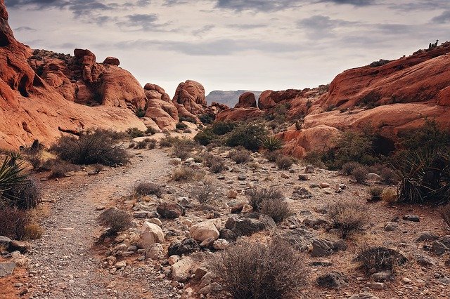
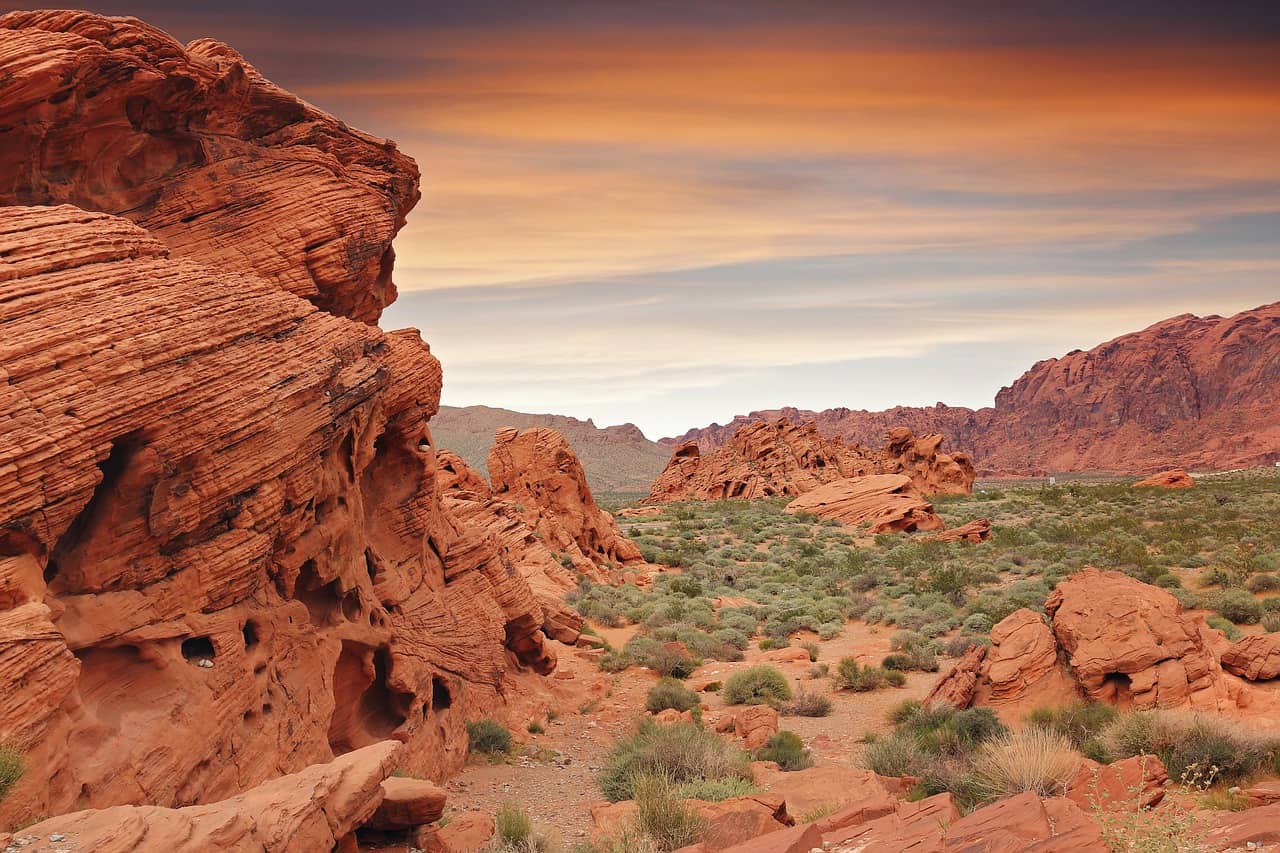
Red Rock Canyon is located just 25 miles west of Las Vegas and is by far the closest and most popular hiking adventure destination compared to the rest of the Las Vegas hiking adventure areas. Because of this though Red Rock Canyon also tends to be the most crowded especially on the weekends.
The Red Rock Canyon National Conservation Area which encompasses 197,349 acres is known for its high peaked red sandstone, the Keystone Thrust Fault, as well as Native American petroglyphs.
Before setting out on your hiking adventures a great place to get the lay of the land is the Red Rock Canyon Visitor Center which is open from 8:00 a.m. to 4:30 p.m. year-round. As it has a ton of useful information about the area and all the things you need to see while there.
Ice Box Canyon Trail
- Distance: 2.3 Miles (round trip)
- Difficulty: Moderate
- What You See: Waterfall, Desert Flora, Canyon
Ice Box Canyon Trail is one of the most popular trails at Red Rock Canyon. When first starting you will be hiking across the open desert where you will see a variety of desert flora and cacti. Once you reach the canyon your surroundings dramatically change from open desert too much tighter canyon walls and the trail begins to follow a small stream.
Eventually, the trail starts to become pretty rocky and some scrambling over rocks and boulders is required. After hiking a little longer the canyon walls begin to narrow before you are met with a small waterfall at the end of the trail.
If you don’t have a lot of time to spend at Red Rock Canyon this a great trail to take as it lets you experience much of what Red Rock Canyon has to offer all on one trail.
Calico Tanks Trail
- Distance: 2.6 Miles (round trip)
- Difficulty: Moderate
- What You See: Distant View of Las Vegas, Large Pools of Water, Wildflowers, Wildlife
Calico Tanks is another very popular trail at Red Rock Canyon and can be a very crowded hike depending on when you go. Also, it’s worth pointing out there is not a lot of parking for this trailhead and parking spaces do fill up so it’s best to visit this trail early in the morning before it gets too crowded.
This trail begins at the Sandstone Quarry trailhead off of Scenic Drive. There is a slight uphill elevation change throughout this trail but it’s hardly noticeable in most areas and the trail should be manageable for most hikers.
This trail is nice because the scenario is always changing creating a very interesting hike and while there really is very little scrambling required on this trail there is plenty of optional scrambling on rocks and boulders for better views and just for the fun of it if you choose.
As the trail name implies there are actually two tanks or pools of water on this trail the first one being smaller and the second one being much larger providing an interesting geological area to check out along the trail.
Finally, at the end of the trail which is also the highest point of elevation you are rewarded with a great distant view of Las Vegas and the surrounding mountains.
First Creek Trail
- Distance: 3.4 Miles (round trip)
- Difficulty: Moderate
- What You See: Views of the Surrounding Mountains, Waterfall with Large Pool Of Water
The last trail in Red Rock Canyon Conservation Area that should be high on your list to check out is the First Creek Trail. This trail has a wide variety of sights along the trail including mountain views, open deserts, and a waterfall.
The First Creek Trail is a wide and well-established trail that sees a lot of traffic and can be crowded at times as with the other trails in the Red Rock Canyon Area. The trail starts at the First Creek trailhead off of Blue Diamond Road.
The beginning of the hike consists mostly of hiking across the flat open desert with very little shade so make sure to bring plenty of water to stay hydrated while on the trail.
While the waterfall is one of the main attractions on this trail be aware that it is not located directly on the trail. In order to view and reach the waterfall, you need to look for a large pine tree on the right side of the trail while hiking. Then you need to turn directly to your right and walk about 100 feet in order to reach the top of a secluded and hidden waterfall.
Keep in mind if you are wanting views or pictures from the base of the waterfall you will have to do quite a bit of scrambling on rocks and boulders to reach the base of the falls.
Las Vegas Overlook Loop
- Distance: 6.3 Miles (round trip)
- Difficulty: Difficult
- What You See: Views of Las Vegas, Wildlife, Large Vistas
While the Las Vegas Overlook Loop is not technically in the Red Rock Canyon area, it is very close to it and located just to the southeast of Red Rock Canyon.
The Las Vegas Overlook Loop is one of the longer and more challenging Las Vegas hiking adventures on this list but it offers amazing vistas and views of Las Vegas as a reward.
The Loop also has the most elevation change of any other hiking adventures on this list with over 1000 feet of elevation change.
On this trail, you are basically hiking out towards the Muffins Ridge and a trail that goes along the edge of Blue Diamond Hill before returning on a mountain bike trail affectionately referred to as the “Boneshaker”.
Much of this trail was formed by horseback riders and mountain bikers so once you reach the Blue Diamond Hill you will find tons of trails and hikes that crisscross the main path that you can take to add additional distance to the trail if you feel like the 6.3 miles just isn’t enough.
Best Hiking Adventures at Valley of Fire
Valley of Fire State Park is another popular destination for Las Vegas visitors looking for some epic hiking adventures during their stay. One of the reasons Valley of Fire is so popular with Las Vegas visitors is that it’s only about 50 miles away from the Las Vegas strip making it a quick drive from Sin City.
Valley of Fire does share some similarities in appearance to Red Rock Canyon Conservation Area but they both have their own unique claims to fame and popular destinations.
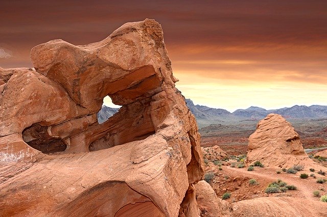
This 46,000-acre state park is famous for its bright red Aztec sandstone, ancient petrified trees, and Native American petroglyphs from over 2,000 years ago. The park is open daily from sunrise to sunset and it only cost $10 to enter the park.
Fire Wave Trail
- Distance: 1.2 Miles (round trip)
- Difficulty: Easy
- What You See: Large Vistas, Unique Rock Formation called the Fire Wave
Fire Wave Trail is one of the main attractions and trails at the Valley of Fire and it’s also family-friendly so just about anyone should be able to complete the 1.2-mile hike.
When you first start out on this trail you are walking across loose sand as it snakes around massive red stone peaks as you head towards Fire Wave. Once you reach the Fire Wave you will want to grab your camera as the formations and layering on the rocks truly make the rock look like a wave on fire hence the name.
Make sure to leave plenty of time while hiking this trail to explore and take pictures of the Fire Wave and if you are looking for some truly otherworldly shots make sure to visit this area an hour after sunrise or an hour before sunset.
White Domes Hike
- Distance: 1 Mile (loop)
- Difficulty: Moderate
- What You See: Movie Set, Slot Canyon
White Domes Hike is another great hiking trail at Valley of Fire that has been used in several TV shows and movies over the years.
The trail starts out on soft sand before transitioning to stone stairs that follow along the side of a cliff down to the basin below. From this point, the hiking trail heads into a slot canyon with narrow and tight twisting walls. Before finally opening up into the open desert with some natural rock arches and wide-open views.
Best Hiking Adventures at Sloan Canyon
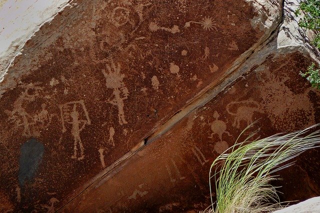
Sloan Canyon National Conservation Area is only about 30 minutes from Las Vegas and has one of the largest collections in the area of Native American petroglyphs with the highest concentration located in Petroglyph Canyon.
Sloan Canyon has around 300 rock art panels with over 1700 unique designs throughout the conservation area.
In 2002 congress protected this area of 48,438 acres in the Mojave Desert so that current visitors and future visitors could appreciate the beauty and tranquility of the desert as well as the petroglyphs.
Trail 100 to Petroglyph Canyon
- Distance: 4.4 Miles (partial loop)
- Difficulty: Moderate
- What You See: Large Vistas, Wildlife, Wildflowers, Petroglyphs
The trail begins on Trail 100 in Sloan Canyon that travels through a large open area desert. The trail continues until you reach a fork in the trail with Trail 200 leading to the west and Trail 100 heading east.
Stay on trail 100 continuing through a few narrow sections of rock that require a little light rock scrambling.
There are petroglyphs scattered throughout the hillside in this area so make sure you take your time to see it all.
Once you are done viewing all the petroglyphs in the area continue south on Trail 100 until you reach the second junction with Trail 200.
This time take Trail 200 to head back north and to meet up with the original junction of Trail 200 and Trail 100 where you will continue on Trail 100 to bring you back to the trailhead where you started.
Black Mountain Trail
- Distance: 6.8 Miles (round trip)
- Difficulty: Difficult
- What You See: Large Vistas, Joshua Trees, Wildlife
The Black Mountain Trail is one of the more popular trails in the Sloan Canyon area but it is also a challenging hike that will require level 2 rock scrambling so it’s not a trail for everyone.
To take this trail you will start out at Shadow Canyon trailhead and follow along a section of the Anthem East Trail which is paved. Keep to the right of the reservoir and look for a sign that reads BLM404 which is the trail that will lead you to Black Mountain.
You want to keep moving along the top of the spillway until you finally see a sign marked “Black Mount Trail”. From this point, the trail is pretty easy to see and well marked so you shouldn’t have any problems following it.
If you are hiking this trail in warm weather make sure to bring plenty of water for hydration while hiking as there is very little shade on this trail.
Best Hiking Adventure at Leak Mead
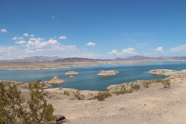
Lake Mead National Recreation Area is not only the first Recreational Area in the US but also the largest encompassing a mind-boggling 1.5 million acres. The Lake Mead area has something for just about everyone including two large lakes, canyons, nine separate wilderness areas, Joshua trees, and red rocks.
Also, as with the other epic hiking adventures on this list, Lake Meade is only about 30 miles away from Las Vegas making it an easy destination to get to from Vegas.
While you can do everything from boating to swimming at Lake Meade we are going to be focusing on all the amazing hiking that you can do while your there.
Fortification Hill Hike
- Distance: 4 Miles (round trip)
- Difficulty: Difficult
- What You See: Large Vistas, Views of Lake Mead, Wildlife
Fortification Hill Hike is located close to the Hoover Dam and the Black Mountains and is a challenging hike only for the most physically fit and capable hikers.
The hike starts with loose sand at your feet as you snake through the Mojave Desert and desert vegetation. The trail is easy to follow as it climbs towards the eastern side of a mesa called Fortification Hill.
Be forewarned though that this is where the trail gets difficult as it requires level 3 rock scrambling up the side of the basalt rock face as you make your way to the top of the mesa of Fortification Hill.
There is a trail to make it up the side of the rock face and to the top of Fortification Hill and it is imperative that you stay on it and take your time in order to stay safe while on this hike.
From this vantage point, you can see the western side of Lake Mead, the Spring Mountains, the Muddy Mountains, and the Virgin Mountains.
Once you have thoroughly taken in all the views that Fortification Hill has to offer, you will continue on the trail west until you reach the summit cairn.
Historic Railroad Trail
- Distance: 7.5 Miles (round trip)
- Difficulty: Easy
- What You See: Old Railroad Tunnels, Elevated Views of Lake Mead, Boulder Basin
If you are looking for something a little less strenuous than Fortification Hill Hike then Historic Railroad Trail might be right up your ally. This trail is wide and covered in gravel making it family-friendly for the whole family.
The Historic Railroad Trail consists of 5 tunnels as you make your way towards Hoover Dam. There is also plenty to learn while you are on the trail as there are multiple informational signs about the surrounding area and wildlife.
This is a nice relaxing trail that lets you take in all the wonders of nature while on a leisurely hike.